15 min City is an instance of the whatif-machine platform, based on the "15-minute city" concept visualising the results
described in the Nature Cities paper.
According to this novel idea, we should conceive cities to be compact, so that their citizens could satisfy their personal needs by
travelling no more than 15 minutes away from their home by bike or on foot. These needs should include goods, work, sport and cultural activities.
This novel paradygm could decrease the emissions of CO2, decongest streets and public transportation, and increase the life quality of the city’s inhabitants.
The 15 min City platform lets you explore how much worldwide cities are close to this ideal, by merging open data about venues within cities, population grids and routing algorithms. With 15 min City, you can check which activities or places are accessible to a neighbourhood on foot and by bike, and compare it to other urban areas. You can also check which city is the closest to the 15 minutes ideal looking at our city rankings in the map. In the following we address the main tools that are present in the platform.
You can use the upper left corner menu to switch between the time on foot or by bike using the corresponding icons. The drop-down menu lets you explore the map for various venues separately, considering only:
For some cities it is possible to visualise our ideal scenario for the city by clicking on the corresponding link on the upper left.
Hygor Piaget Monteiro Melo (Sony CSL Rome)
Bruno Campanelli (Sapienza University of Rome)
Vittorio Loreto (Sony CSL Rome)
Former contributors:
Bernardo Monechi (Sony CSL Paris)
Enrico Ubaldi (Sony CSL Paris)
Claudio Chiappetta (Sapienza University of Rome)
The 15 min City platform lets you explore how much worldwide cities are close to this ideal, by merging open data about venues within cities, population grids and routing algorithms. With 15 min City, you can check which activities or places are accessible to a neighbourhood on foot and by bike, and compare it to other urban areas. You can also check which city is the closest to the 15 minutes ideal looking at our city rankings in the map. In the following we address the main tools that are present in the platform.
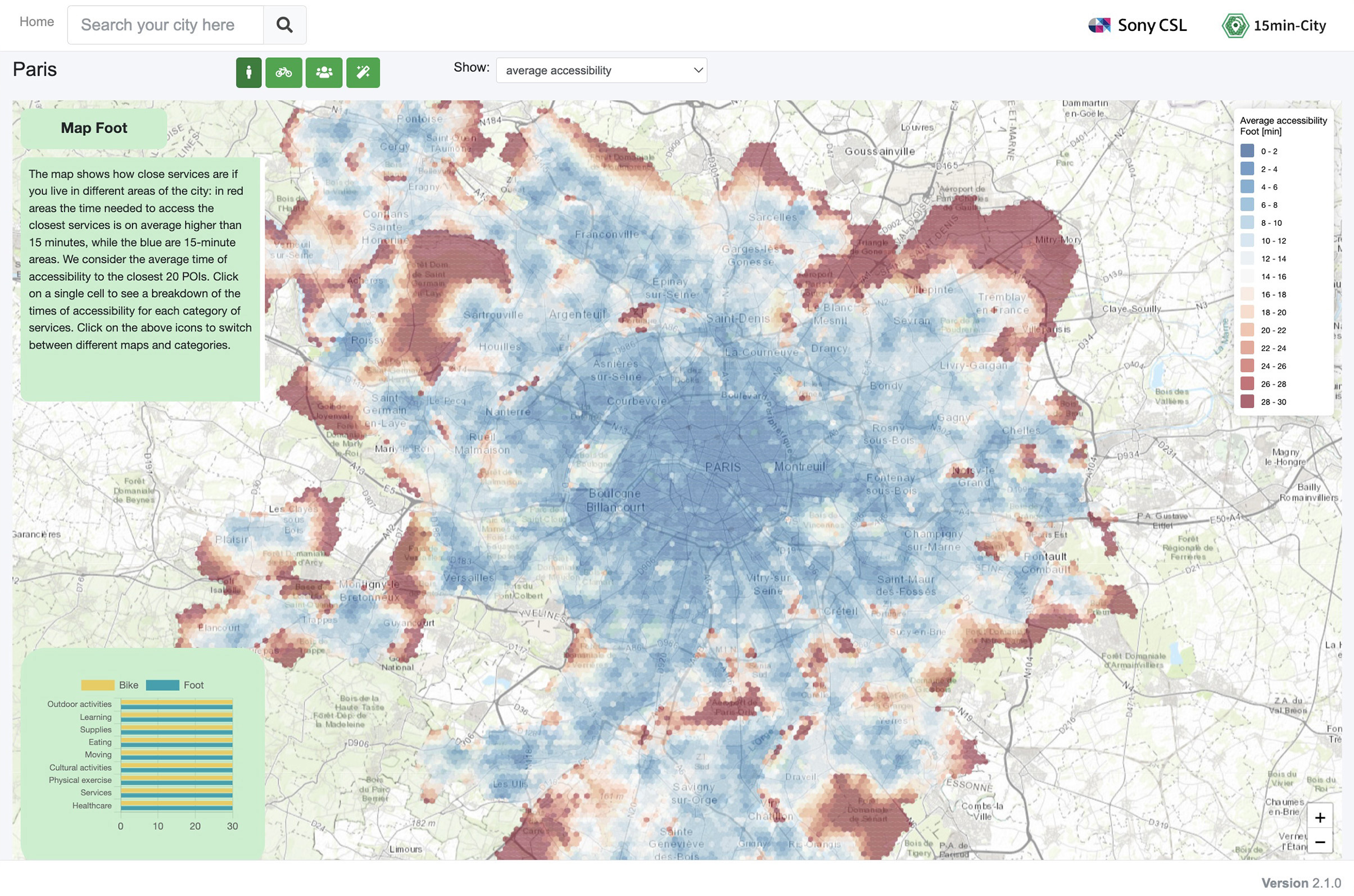
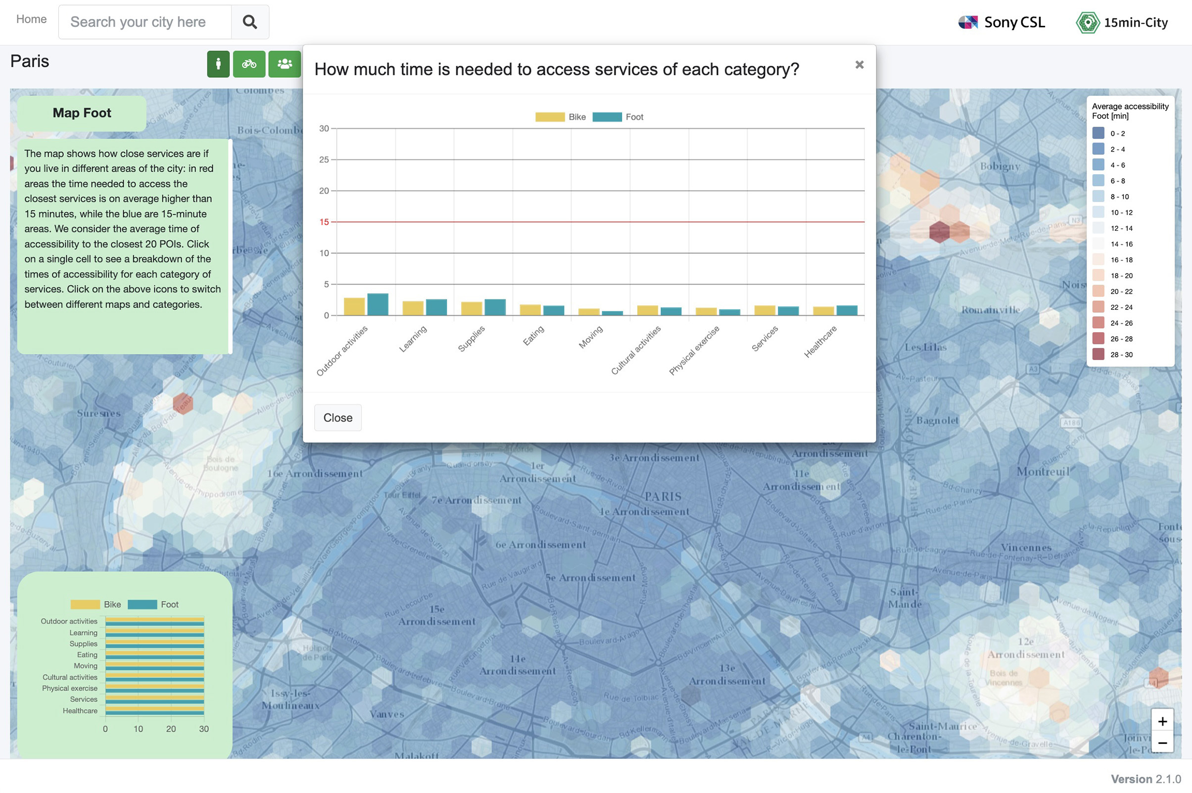
Accessibility Maps
These maps will tell you how much an area is "15 Minutes". Each area's colour represents the average travel time for an individual to reach its daily activity venues on foot or by bike. If this travel time is below 15 minutes, the area colour will be blue, red otherwise.You can use the upper left corner menu to switch between the time on foot or by bike using the corresponding icons. The drop-down menu lets you explore the map for various venues separately, considering only:
- Outside activities: parks, walks, picnics...
- Learning: schools, universities...
- Supplies: supermarkets, grocery stores…
- Eating: restaurant, bistros, cafes...
- Moving: bus stations, train stations, taxis...
- Cultural Activities: museums, theatres, cinemas...
- Physical Exercise: Gyms, Sports Centers...
- Services: offices, banks, post office, town halls...
- Healthcare: hospitals, doctors, pharmacies...
For some cities it is possible to visualise our ideal scenario for the city by clicking on the corresponding link on the upper left.
Technical Details and Credits
Matteo Bruno (Sony CSL Rome)Hygor Piaget Monteiro Melo (Sony CSL Rome)
Bruno Campanelli (Sapienza University of Rome)
Vittorio Loreto (Sony CSL Rome)
Former contributors:
Bernardo Monechi (Sony CSL Paris)
Enrico Ubaldi (Sony CSL Paris)
Claudio Chiappetta (Sapienza University of Rome)
Partnership
Riccardo Corradi (I-Lab, https://www.ilabroma.com/)Citation
Bruno, Matteo, Hygor Piaget Monteiro Melo, Bruno Campanelli, and Vittorio Loreto. "A universal framework for inclusive 15-minute cities." Nature Cities 1, no. 10 (2024): 633-641.MAP