

What would happen if cities were built more sustainably? What if my city had more services, bike lanes, or metro lines? The intrinsic complexity of the emerging challenges human beings collectively face requires a deep comprehension of the underlying phenomena in order to plan effective strategies and sustainable solutions: from the planning of urban infrastructures to rethinking cities and their interactions, from containment strategies for pandemics to the impact of political campaigns to measures against information pollution and misinformation. In all these cases, decision-making processes have to be supported with meaningful representations of the present situations along with accurate simulation engines to generate and evaluate future scenarios. Instrumental to all this is the possibility to gather and analyze huge amounts of relevant data and visualize them in a meaningful way, also for an audience without technical or scientific expertise. Understanding the present through data is often not enough and the impact of specific decisions and solutions can be correctly assessed only when projected into the future. Hence the need of tools allowing for a realistic forecast of how a change in the current conditions will affect and modify the future scenario.
The whatif-machine is a Sony CSL platform aimed at providing users with tools to assess the status of urban and inter-urban spaces and conceive new solutions and new scenarios. The whatif-machine platform is modular and new layers can be easily added depending on the needs. Below you can choose a module to access it.

Timing Urban Spaces
15min-City is a platform that lets you assess how far a city is from the 15-minute city ideal. According to this model, a liveable and sustainable city should allow citizens to satisfy most of their social, economic and material needs with few displacements: ideally within 15 minutes on foot or by bike from their homes. With 15mincity, it is possible to explore which parts of worldwide cities adhere to this concept, and which are the most 15-minute cities. Start by choosing a city on the map. Read more.
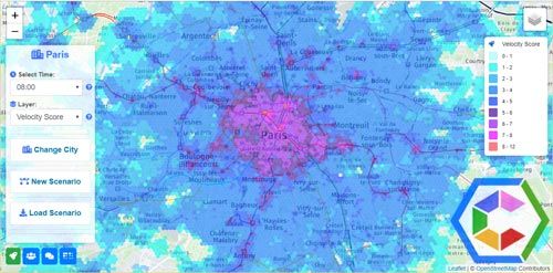
Timing Urban Spaces
CityChrone++ lets you explore in a very intuitive way the accessibility of urban areas by public transportations systems. The basic idea is to represent urban spaces in a way closer to people's perception where distances are replaced by traveling times. CityChrone++ provides you with a powerful tool to assess the present status of urban accessibility and design and evaluate future scenarios. Start out by choosing a city on the map. Read more.
Build Your Ideal City
Kreyon City is an immersive experience that allows users to play with urban scenarios, exploring the space of possible solutions to issues like employment, education and quality of life the more general sense. The backbone of Kreyon City is a data-driven mathematical model of urban indicators that can be tuned with heterogeneous data sources coming from different nations and different time frames. Read more.